Description
Description
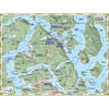
Heading into this region, you'll leave behind the population hubs of Quadra and Cortes Island, moving into the more remote northern waters where both attractions and challenges await. Most paddlers stick to Okisollo Channel, known for its abundant camping options, often making their way to Octopus Islands, the area's main provincial park. For those exploring further, they’ll encounter secluded campsites, scattered parks, and mostly tidal passages rarely visited.
Features:
- Created by kayakers and explorers with expert knowledge of the region.
- Covers North Quadra Island, Sonora Island, the Octopus Islands, and extends south to Surge Narrows. The reverse side offers a detailed expanded view of Surge Narrows.
- Includes all key land and marine features, such as campsites, launch points, rest stops, attractions, and hazards.
- UTM grid lines for accurate distance measurements— Learn to understand and make the most of them.
- Printed on highly durable, waterproof 10-mil stock (a thicker, more resilient option compared to the typical 4.3-mil stock).
- Planning and logistical details provided on the reverse side of the main map to help you prepare for your adventure.
- Optimized size and format for both home planning and on-water use.
- Enhance GPS navigation with a clear visual overview for route planning and daily activities. Together, they’ll prepare you for a well-informed journey.
- Navigate traditionally without electronic devices—no need for batteries or connectivity, allowing you to truly disconnect.