Description
Description
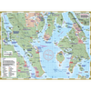
Quadra and Cortes Islands are the largest within the Discovery Islands archipelago, a diverse region that also encompasses East and West Thurlow Islands, Sonora, Maurelle, Read, the Rendezvous Islands, Stuart, and East and West Redonda Islands. Known for its meandering waterways, scenic mountain backdrops, and pristine shorelines, the Discovery Islands have become a popular tourist destination. It offers a unique opportunity to escape into nature without the challenges or long travel distances typical of more remote coastal areas. The region is also rich in land features, making it ideal for exploration both on and off the water.
Features:
- Designed by kayakers and explorers with expert knowledge of the region.
- Includes full coverage of Cortes Island and Quadra Island to Surge Narrows, and pairs with mapsheet #235 North Discovery Islands for a comprehensive regional overview.
- Highlights all key land and marine features, including campsites, launch points, rest stops, attractions, and hazards.
- UTM grid lines for easy distance calculations—Learn to understand and make the most of them.
- Printed on ultra-durable, waterproof 10-mil stock (a more robust option compared to the standard 4.3-mil stock).
- Planning and logistical details are provided on the reverse side of the main map to help bring your adventure to life.
- Optimal size and format for both home planning and on-water use during your travels.
- Enhance your GPS navigation with a clear visual overview to help plan your journey and daily activities. Together, these tools will ensure you're well-prepared for your adventure.
- Navigate traditionally without relying on electronics—no need for batteries or connectivity, allowing you to truly disconnect.